(12-28-2015, 03:16 PM)ggaliens Wrote: "The two poles must be the same diameter as well as they must be a perfect circle".That doesn't need to be said if you know about the concept.
I gathered some of the above ... from experiments. But this information is not on status line is it ?
You are using a "wrong" mesh for this method. I could to try explain, but my English and knowledge isn't enough, so I got this text from this link.
You can find many others - all of them you will be using a regular Sphere and the Sphere map will unwrap it in a Cylinder creating a rectangle map.
Quote:Map Coordinate SystemsThe kind of mesh you are using would require a regular Unfold, maybe.
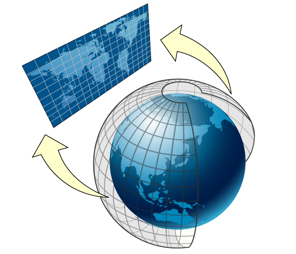
To understand the coordinate systems used by Map Kit, it helps to understand how the three-dimensional surface of the Earth is mapped to a two-dimensional map. Figure 5-1 shows how the surface of the Earth can be mapped to a two-dimensional surface.
Figure 5-1 Mapping spherical data to a flat surface
Map Kit uses a Mercator map projection, which is a specific type of cylindrical map projection like the one shown in Figure 5-1. In a cylindrical map projection, the coordinates of a sphere are mapped onto the surface of a cylinder, which is then unwrapped to generate a flat map. In such a projection, the longitude lines that normally converge at the poles become parallel instead, causing land masses to be distorted as you move away from the equator. The advantage of a Mercator projection is that the map content is scaled in a way that benefits general navigation. Specifically, on a Mercator map projection, a straight line drawn between any two points on the map yields a course heading that can be used in actual navigation on the surface of the Earth. The projection used by Map Kit uses the Prime Meridian as its central meridian.
How you specify data points on a map depends on how you intend to use them. Map Kit supports three basic coordinate systems for specifying map data points:
- A map coordinate is a latitude and longitude on the spherical representation of the Earth. Map coordinates are the primary way of specifying locations on the globe.
- A map point is an x and y value on the Mercator map projection. Map points are used for many map-related calculations instead of map coordinates because they simplify the mathematics involved in the calculations. In your app, you use map points primarily when specifying the shape and position of custom map overlays.
- A point is a graphical unit associated with the coordinate system of a view object. Map points and map coordinates must be mapped to points before drawing custom content in a view.
I just tried to drive your mesh in that direction in order to get the desired result. That is because we cannot automatize everything - the human eye and brain still work better for most situation.


![[Image: tw.png]](https://i.postimg.cc/QdjwyGVz/tw.png) @MicheusVieira
@MicheusVieira ![[Image: yt.png]](https://i.postimg.cc/WpJBDwQ5/yt.png) @MicheusVieira
@MicheusVieira ![[Image: da.png]](https://i.postimg.cc/xTvB5TjH/da.png) Micheuss
Micheuss ![[Image: ig.png]](https://i.postimg.cc/4xMvhpC1/ig.png) micheus4wings3d
micheus4wings3d